Picterra
AI-Powered Geospatial Solutions: Enhancing Lives, Serving Purposes, and Protecting Our Planet In today's rapidly evolving world, AI-powered geospatial solutions are transforming the way we understand and interact with our environment. These innovative technologies harness the power of artificial intelligence to analyze spatial data, providing insights that benefit individuals, organizations, and the planet as a whole. Empowering People: With user-friendly interfaces and intuitive designs, these solutions make it easier for individuals to access and utilize geospatial data. Whether for personal projects or community initiatives, AI-driven tools enhance decision-making and foster collaboration. Purpose-Driven Applications: Organizations across various sectors are leveraging AI geospatial solutions to achieve their goals. From urban planning to disaster management, these tools enable precise analysis and strategic planning, ensuring that resources are allocated effectively. Planet-Friendly Innovations: As we face pressing environmental challenges, AI-powered geospatial solutions play a crucial role in sustainability efforts. By providing accurate data on land use, climate change, and natural resources, these technologies help us make informed decisions that protect our planet. AI-powered geospatial solutions are not just tools; they are catalysts for change. By enhancing lives, serving meaningful purposes, and protecting our planet, these technologies are paving the way for a more informed and sustainable future. Embrace the power of AI in geospatial analysis and unlock new possibilities for yourself and your community.Why Choose AI-Powered Geospatial Solutions?
Key Features of AI-Powered Geospatial Solutions
Conclusion
Category:marketing advertising-assistant
Create At:2024-11-24
Picterra AI Project Details
What is Picterra?
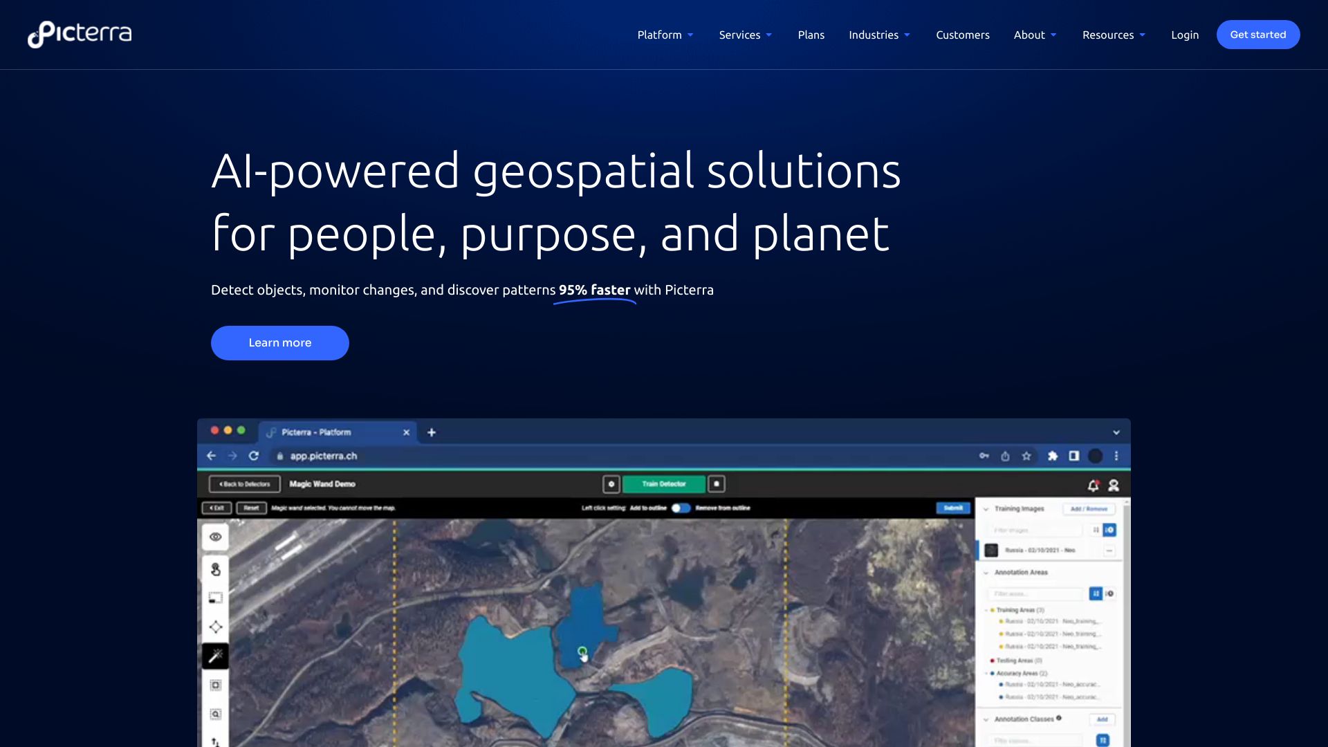
Picterra is a software platform for the training, deployment, and management of machine learning models powering geospatial apps and business services. It provides AI-powered geospatial solutions for detecting objects, monitoring changes, and discovering patterns in satellite, drone, and aerial imagery 95% faster.
How to use Picterra?
Picterra's cloud-native AI platform allows users to optimize geospatial workflows, detect objects faster, and drive sustainable action. The platform provides tools for imagery sourcing and processing, detector training support, change detection, tracking, and monitoring, as well as dashboard and results customization.
Picterra's Core Features
- AI-powered geospatial solutions
- Training, deployment, and management of machine learning models
- Detection of objects, monitoring of changes, and discovery of patterns in satellite, drone, and aerial imagery
- Cloud-native platform for optimizing geospatial workflows and driving sustainable action
- Imagery sourcing and processing
- Detector training support
- Change detection, tracking, and monitoring
- Dashboard and results customization
Picterra's Use Cases
- Forestry and carbon markets
- Agriculture and regenerative farming
- Mining and quarries
- Infrastructure
- FMCG and commodities
FAQ from Picterra
What industries can benefit from Picterra's geospatial AI solutions?
What are the core features of Picterra's platform?
What can Picterra help me achieve in terms of efficiency and productivity?
Contact Picterra
For support, email & customer service contact & refund contact, visit the contact us page.
About Picterra
Picterra Company name: Picterra. For m